Honorable Mr. Jesús Gómez, Undersecretary of Transport and Sustainable Mobility, distinguished authorities, ladies and gentlemen,
It is an immense honor and a profound satisfaction for me to receive, on behalf of the gvSIG Association, the first National Geographic Science Award ever given in Spain. We humbly confess that being the first to receive it, with so many deserving individuals and entities, further elevates the importance we place on this award. Additionally, it ensures that you will hear the best acceptance speech for the award to date.
This award represents an extraordinary recognition of the trajectory and dedication of a group passionate about geography, technology, and knowledge, understood as drivers of change.
Let us begin with the term that names this award, geography. Tim Marshall, in his excellent essay “Prisoners of Geography,” concluded that while geography does not dictate the development of all events, since great ideas and leaders are part of the push and pull of history, all must act within the confines that geography sets. Former U.S. President Barack Obama told us that geography was much more than putting names on a map; it was about understanding reality. Those who have listened to us over the years well know that in the gvSIG Association, we have always affirmed that reality manifests in the territory. Everything exists to the extent that it is in a place and how it relates to what is around it. Therefore, the geographic or spatial dimension of things is a fundamental attribute for managing reality. It was in the past, it will be in the future, and undoubtedly, it is in the present.
This leads us to talk about the second concept that excites us, technology. With more than two decades into the 21st century, we must all be aware that technology permeates every productive, economic, academic, and social process to the point of becoming an indispensable tool. Without fear of being wrong, I could say that there are more technological devices in this room than people. We cannot imagine that management of reality we spoke of without technology. We know that Spain and the European Union are significantly betting on science, technology, and innovation as fundamental pillars for their growth and sustainable development. For our part, in the gvSIG Association, we have always talked about technology as a strategic sector and will continue to insist on it as long as necessary. Geographic information management technologies, encompassed under the concept of geomatics, are those that allow us to analyze, understand, and manage the territory, geography.
Geomatics is applied in managing infrastructures of all kinds, in sectors such as the environment, security, energy, mobility, education, health, agriculture, tourism,… it is transversal to countless themes and applicable to countless geographies.
Thus, we should begin to be aware that being dependent on a strategic sector is a manifest weakness. Who would want our administrations, our universities, our companies, those that work in and with the territory, to be technologically dependent? Herein lies much of the importance and success of the gvSIG project: building and developing technologies for managing spatial data, its geographic dimension, with free software. Betting on technological sovereignty by promoting solutions that grant all rights and freedoms to their users. That avoid any dependence not only on technologies but on the owners of these. Not only that, the gvSIG Association has fostered its own industrial fabric, specialized in geomatics, making the Valencian Community and Spain a reference center internationally. Today, not only are gvSIG-branded technologies used worldwide, but today, Spanish companies carry out some of the largest projects related to geographic information systems around the globe. I conclude this section by reaffirming that betting on our own and free technologies can be, undoubtedly is, a strategic decision of the highest order.
We link this to the last concept related to the gvSIG Association’s activity, knowledge. And at this point, it might be worthwhile to take a look back at the history of our entity.
Let us not forget that if we are here today, receiving this important recognition, it is because one day a public administration, the Generalitat Valenciana, decided to take the first step. The gvSIG project came to light in 2004, with a first version of a software product that today is part of a complete catalog of geomatics solutions. Today, not only is it talked about, but legislation in Spain and Europe promotes reuse, sharing, interoperability among administrations, and the development of our own technologies. At the beginning of this century, it was not so. The Generalitat Valenciana not only took the first step but knew how to share the achievements with the entire international community and energize what would end up being the gvSIG Association.
Today, it continues to bet on the project, using gvSIG technologies in more and more areas, from agriculture to road safety, from industry to sustainable mobility, contributing to its development and also reusing all the technological improvements that are continuously consolidated in the project. Just last week, the Danish Agency for Digital Government published a report highlighting the Generalitat Valenciana as the main success case for the promotion of free software technology by a public administration. It spoke of gvSIG.
Therefore, this award, this recognition, is largely shared with the Generalitat Valenciana and, in particular, with its Directorate General of Information and Communication Technologies.
At the end of 2009, the gvSIG Association was born. A group of people, companies, and entities decided to scale the impact of the project. To ensure its sustainability on the one hand, to consolidate an incipient industrial fabric on the other. The premise might seem simple, but it was not easy to implement. Bringing the values of free software to the economy. Developing a new business model – a concept much talked about – based on collaboration, shared knowledge versus speculation with acquired knowledge, solidarity versus rivalry. From the dates, you may guess that we were born in the midst of a crisis, in difficult times, with few resources but with great enthusiasm. In those early years, we made the English proverb “A smooth sea never made a skilled sailor” our own. It was necessary to dream, and believing in our dreams has brought us here. After this time, we do not forget to keep dreaming.
Today, in 2024, the gvSIG Association is an entity recognized worldwide. The technology derived from a project born, let us not forget, on the periphery of Europe is used in more than 160 countries. We participate and collaborate with the main forums and organizations that promote Geographic Sciences, open knowledge, and interoperability. We have received international awards from entities such as NASA or the European Commission, which last year recognized gvSIG as the most important free software project in Europe. We have developed a suite or catalog of free technologies that allow addressing any need for information management with a geographic dimension, for any organization. We collaborate on R+D+I projects with dozens of universities, scientific publications citing the use of gvSIG are multiplying. gvSIG’s social networks have a notable influence with thousands of followers. And regarding that new business model we talked about… we have promoted the consolidation of Spanish companies and developed projects in more than 30 countries for entities of all kinds, from the United Nations to small municipalities, from large private sector energy companies to NGOs. We are, in short, an international reference center.
Our history, therefore, pivots around knowledge. Developing it to share it, to reduce asymmetries between territories, to generate quality economy, to reaffirm Antonio Machado’s saying that “in matters of culture and knowledge, you only lose what you keep; you only gain what you give.”
I want to recall an anecdote that well reflects this phrase. An example of those other values, not quantifiable, that occur around the model of knowledge, development, and business we promote in the gvSIG Association.
At an event organized by Itaipú Binacional in Foz do Iguaçu, Brazil, we were invited to give training courses both to the staff of the hydroelectric plant and, openly, to university students who wanted to attend. In the first training course, a male and a female student sitting in the front row asked the trainer (in this case, it was me) if he could put them in touch with the event organizers to ask for affordable accommodation. Then they told me their story…
At the University of Asunción, Paraguay, where they were studying, the students collectively requested the faculty to give them training in gvSIG, as they considered it a strategic investment for the country to have engineers trained in free software technologies, with all the advantages that entails. The faculty, familiar only with non-free products, refused. Among all the students, it was decided to collect funds to allow one male and one female student to make the long journey to Foz do Iguaçu, receive training, and thus, upon returning, be able to replicate the training for all the students. Today, several of those students hold responsible positions in the country.
If we have come this far, it is because many people think there can be other approaches, other ways of doing things. Therefore, to conclude, I want to thank all the people who were, are, or will be in the gvSIG project: workers, entities, communities… and especially to the colleagues for their effort and commitment, who have always put themselves at the service of the project and never put the project at their service. Our future will be full of maps, standards, algorithms, and lines of code, but above all, of people working towards a common goal. Thank you very much.
 A BLACK FRIDAY DA GEOCURSOS VEM AÍ!


 Django
 Funcionalidades GIS avançadas: GeoDjango oferece ferramentas prontas para manipulação e visualização de dados geoespaciais.
 Segmentação de Mercado
 Otimização da Cadeia de Suprimentos
 Gerenciamento de Riscos
 Insights sobre o Comportamento do Cliente
 Gerenciamento de Ativos
 Análise de Concorrentes
 Integração de dados em tempo real


 Código aberto não significa um comprometimento da qualidade. Significa flexibilidade.

 Melhore a busca por dados com pesquisa semântica
 Enriqueça seu conjunto de dados extraindo dados estruturados de texto não estruturado
 Conduza seu aplicativo geoespacial com ferramentas e chamadas de função
 Desenvolva habilidades de inteligência de localização com modelos text2sql específicos
 Crie seu chatbot personalizado com agentes

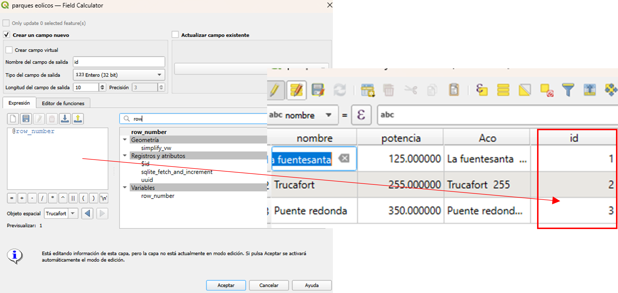
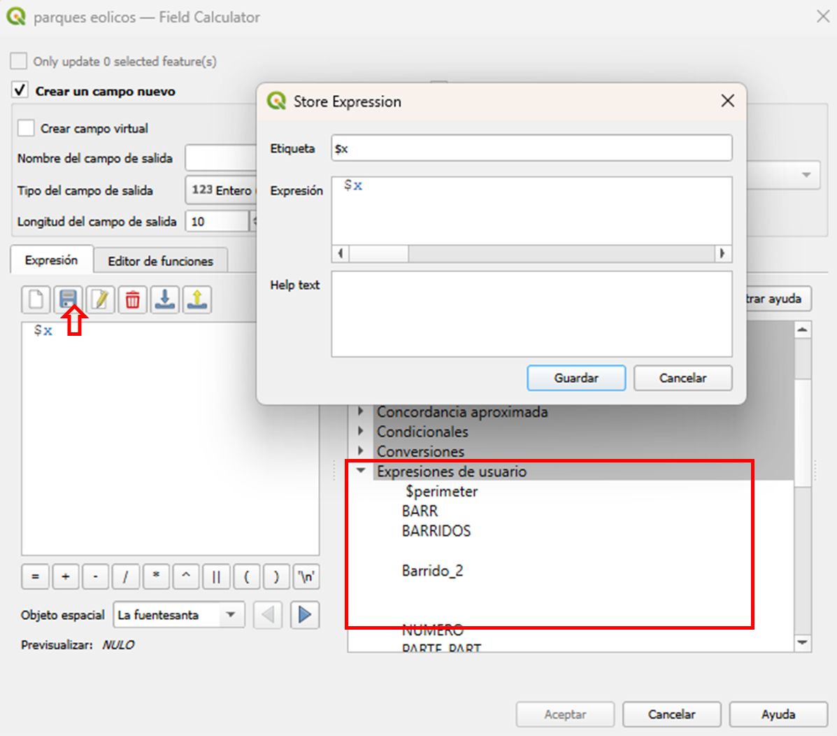


 . Recuerdo que en sus inicios se hablaba mucho de los valores de gvSIG. Los más antiguos posiblemente recordaran eso de “Más, mejor y de una forma más justa” “Un modelo de producción basado en la colaboración y en la solidaridad”, “conocimiento compartido vs especulación con conocimiento adquirido” etc.